LiDAR Collection Services
Innovative Technology for What Lies Beneath
LiDAR is used on a majority of Psomas’ projects for our Energy, Land Development, Transportation, and Water markets. LiDAR, though a highly technical and accurate technology, is a relatively simple concept — a laser light is directed at the earth’s surface (or a specific object) and calculations are derived based on the time it takes for the light to return to its source. Collecting massive amounts of data such as tree canopy, power lines, structures and bare earth in mere seconds, Psomas team then extracts information from the point cloud data based upon client needs.
Psomas is knowledgeable about the many LiDAR collection systems, ground or air based, available on the market and can determine the appropriate system for each project, ultimately saving time and money while offering a range of deliverables specific to each client’s specific job need.
Loream Ipsium Var
Loream Lorispsm
Collection Services
Data gathering, one small part of this process, involves collecting raw data into usable formats based on each client’s goals and desired CAD platforms. LiDAR collection is obtained using several different methods including:
Static collection is used to observe highways, analyze infrastructure, or collect accurate point-cloud data from inside and outside of the built environment. Scanning exterior features such as ADA ramps or interior facility infrastructure, including gathering information for interior building spaces for use in BIM applications produces highly accurate results. Due to its accuracy and flexibility, this affordable technology is incorporated on many of our projects and has vast applications.
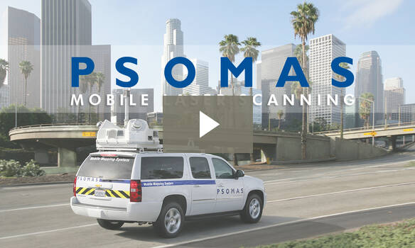
MTLS is a land surveying method with equipment mounted on a vehicle used to collect data in transportation corridors, railways, or for asset collection in the enterprise asset management (EAM) world. MTLS captures both the natural and built environments, is more efficient than traditional surveying, provides fewer interruptions to a site, and is cost efficient by limiting the number of surveyors required. This type of scanning is particularly useful for transportation or railway corridors where access is hazardous or limited.
Airborne LiDAR provides exact measurements gathered by pointing a laser towards the ground surface, which returns to the sensor immediately after hitting the object. Typically using helicopters or fixed wing aircraft to fly the system, difficult-to-reach areas become more readily accessible, helping ensure site safety and capitalize on cost/time efficiencies.
Fixed Wing: Fixed-wing airplane collection combines LiDAR sensing with RGB camera data to enable highly accurate and high-resolution 3D representation and measurement over large areas with minimal flights and in challenging environments.
sUAS: Small unmanned aerial systems provide even more accuracy and increased accessibility over traditional methods of data acquisition. Benefits over manned aircraft and satellite platforms include high spatial